![Item #map013 Verbreitung und Intesitaet des Reisbaus auf der Erde and "Verbreitung und Intesitaet des Reisbaus in Asien" [rice maps]. C. Bachmann.](https://blackpawbooks.cdn.bibliopolis.com/pictures/map013.jpg?width=768&height=1000&fit=bounds&auto=webp&v=1554407161)
![Verbreitung und Intesitaet des Reisbaus auf der Erde and "Verbreitung und Intesitaet des Reisbaus in Asien" [rice maps]](https://blackpawbooks.cdn.bibliopolis.com/pictures/map013_2.jpg?auto=webp&v=1554407160)
![Verbreitung und Intesitaet des Reisbaus auf der Erde and "Verbreitung und Intesitaet des Reisbaus in Asien" [rice maps]](https://blackpawbooks.cdn.bibliopolis.com/pictures/map013_3.jpg?auto=webp&v=1554407160)
![Verbreitung und Intesitaet des Reisbaus auf der Erde and "Verbreitung und Intesitaet des Reisbaus in Asien" [rice maps]](https://blackpawbooks.cdn.bibliopolis.com/pictures/map013_4.jpg?auto=webp&v=1554407160)
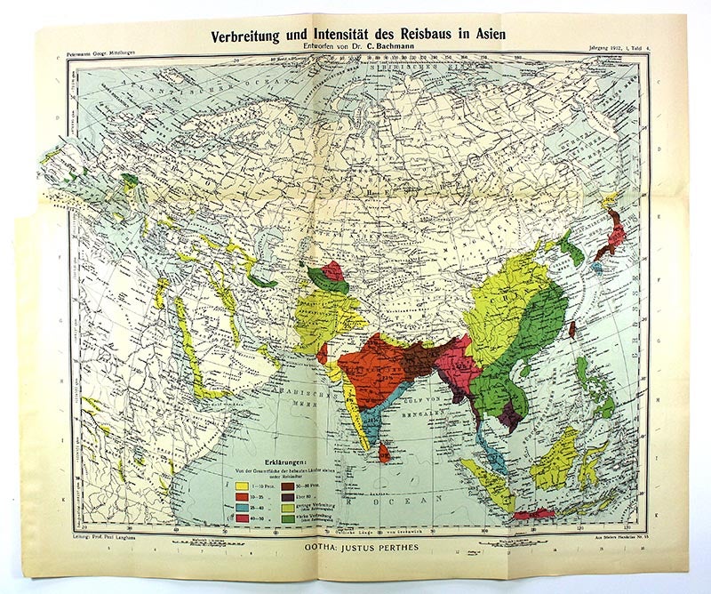
Verbreitung und Intesitaet des Reisbaus auf der Erde and "Verbreitung und Intesitaet des Reisbaus in Asien" [rice maps]
Dr. A. Petermanns Mitteilungen aus Justus Perthes' Geographischer Anstalt, 1912. original folded map. Very Good. Item #map013
Two original folded maps related to rice production by C. Bachmann: "Verbreitung und Intesitaet des Reisbaus auf der Erde" and "Verbreitung und Intesitaet des Reisbaus in Asien" (Dr. A. Petermanns Mitteilungen aus Justus Perthes' Geographischer Anstalt, 1912). Global map is approximately 12 inches tall x 18.5 inches wide; that of Asia, 15 inches tall x 18.5 inches wide. Both maps remain clean and unmarked.
Price: $35.00
See all items in
Ephemera & Maps
See all items by C. Bachmann